
![“greenhouse-gas-84-times-stronger”:-real-time-methane-monitoring-with-ai…unist-detection-technology-developed-[reading-science]-–-the-asia-business-daily](https://sapio.asia/wp-content/uploads/2026/05/37387-greenhouse-gas-84-times-stronger-real-time-methane-monitoring-with-aiunist-detection-6a1479c5af2bc.jpg)
Automatic Detection of Methane Leaks Using NASA Hyperspectral Satellite Data
“Learning Physical Properties, Not Just Colors”…
Next-Generation Greenhouse Gas Monitoring Technology Expected
Artificial intelligence (AI) technology that can automatically detect methane leakage points in satellite images has been developed in South Korea. With this technology, AI can quickly determine whether methane leaks are present without the need for manual satellite image inspection, and it is expected to contribute to the establishment of an international greenhouse gas reduction monitoring system.
On May 25, Ulsan National Institute of Science and Technology (UNIST) announced that Professor Jeongho Lim and his research team in the Department of Urban and Environmental Engineering have developed an AI technology that automatically detects methane leakage plumes using hyperspectral satellite data.
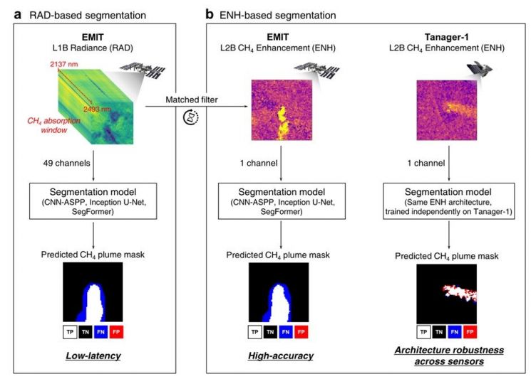
Comparison of Methane Plume Detection Methods Using Hyperspectral Satellite Data. The radiance-based method, which directly utilizes satellite observation signals, is advantageous for rapid detection, while the methane concentration enhancement-based method can more precisely distinguish leakage areas. The research team confirmed that both methods can be reliably applied to different satellite data. Provided by the research team
View original image
Methane is known as a greenhouse gas with a relatively short atmospheric lifetime, but it causes a greenhouse effect about 84 times stronger than carbon dioxide over a 20-year period after emission. In particular, large-scale leaks can occur at oil and gas facilities, waste treatment plants, and coal mining sites, which is why the international community is strengthening monitoring for emission reduction.
The core of this research is that AI can automatically distinguish traces of methane leakage without direct human analysis of satellite images.
The research team trained a deep learning image segmentation model using hyperspectral satellite data from NASA’s Earth Surface Mineral Dust Source Investigation (EMIT) instrument, which is mounted on the International Space Station (ISS). Hyperspectral satellites observe reflected light from the Earth in dozens to hundreds of narrow wavelength bands. Methane absorbs light at specific infrared wavelengths, and this characteristic can be used to identify traces of methane leakage in the atmosphere.
“Learning Methane’s Physical Properties, Not Just Simple Colors”
The AI automatically separated the “plume” shapes of methane spreading in the satellite images. The research team validated its performance using real methane leak cases from oil and gas facilities, waste treatment plants, and coal mining sites in Turkmenistan, Algeria, the United States, and other regions.
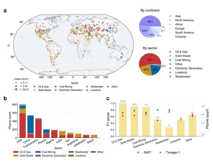
Analysis results of global methane plume distribution and major emission sources detected using EMIT and Tanager-1 satellite data. Methane emissions were concentrated in Asia and North America, with significant leaks identified from oil and gas facilities, waste treatment sites, and coal mining areas. Particularly high detection frequencies were observed in the United States and China, and the AI-based detection model demonstrated stable performance across diverse emission environments. Provided by the research team
View original image
Notably, through explainable AI (XAI) analysis, the team confirmed that the AI was not simply learning image colors or background patterns, but was making decisions based on actual physical characteristics—such as the wavelength bands where methane absorbs light and the plume shapes of the leaks.
Professor Jeongho Lim of UNIST explained, “Methane is a greenhouse gas for which simply detecting where and how much is leaking can significantly enhance reduction efforts. However, previously, it took a long time to process data and for experts to review it. This study is meaningful in that it presents analytical criteria for rapidly screening suspected leakage areas using hyperspectral satellite data and AI, and, when necessary, verifying them in detail.”
The research team also compared and analyzed combinations of two types of satellite data and three types of deep learning image segmentation models to present guidelines for practical application.

Research team photo. (From left) Professor Jeongho Im, Researcher Seyoung Yang (first author), Researcher Yejin Kim (first author), Researcher Mingi Chu, Researcher Hyunyoung Choi. Provided by UNIST
View original image
The model trained on data emphasizing methane concentration enhancement generally showed higher detection accuracy. In contrast, the model learning directly from satellite-observed radiance was relatively less accurate but proved advantageous for rapidly identifying suspected leakage areas without the need for separate preprocessing.
Furthermore, the method validated with NASA EMIT data demonstrated similar performance with data from the private hyperspectral satellite “Tanager-1,” confirming its potential for expansion regardless of the satellite type.
The research team expects this technology to be utilized as a next-generation greenhouse gas monitoring system, capable of early detection and response to large-scale methane leaks.
Researchers Seyoung Yang and Yejin Kim participated as co-first authors in this study, and the findings were published in the international journal ‘npj Climate and Atmospheric Science.’
한글 기사 보기” onclick=”gtag(‘event’, ‘click’, {‘event_category’ : ‘바이라인하단’, ‘event_label’ : ‘원문보기’});”> 한글 기사 보기
This content was produced with the assistance of AI translation services.
© The Asia Business Daily(www.asiae.co.kr). All rights reserved.