Home » Johnson & Johnson MedTech advances surgical robotics with Nvidia AI, plans 2026 launch The Monarch platform for urology leveraging AI-driven simulation with Nvidia accelerated compute. [Image courtesy of Johnson & Johnson MedTech] Johnson & Johnson MedTech (NYSE: JNJ) today announced new advances in surgical robotic technology with physical AI capabilities. The medtech giant
From India to Asia: How Google’s AI is cultivating a new future for agriculture
In a significant move demonstrating the global scalability of “India-first” innovations, Google has announced the expansion of its foundational AI models for agriculture to the wider Asia-Pacific region. The Agricultural Landscape Understanding (ALU) and Agricultural Monitoring and Event Detection (AMED) APIs, which have been empowering an ecosystem of startups and government bodies in India, are now being made available to trusted testers in Malaysia, Indonesia, Vietnam, and Japan.
These freely available models leverage remote sensing and machine learning to provide hyperlocal insights, aiming to solve some of the most deep-seated challenges in agriculture. To understand the technology, its impact, and the vision behind this expansion, I sat down with Alok Talekar, Lead for Agriculture and Sustainability Research at Google DeepMind, and Avneet Singh, a Product Manager in Google’s Partner Innovation team.
The Problem: A Fragmented and Data-Poor Landscape
Agriculture, particularly in a country as vast as India, is not a monolith. It’s a complex, fragmented ecosystem where solutions that work in one state might be entirely ineffective in another. This is the core problem Google set out to address.
When asked about the key challenge his team identified, Alok Talekar was clear. “Largely, everybody wants to do the right thing, but agriculture is very diverse in the country,” he explained. “And they just don’t have the right tools and access to information.”
Historically, agricultural data has been aggregated at a high level – district, block, or perhaps village. According to Avneet Singh, this isn’t granular enough. “The right intervention, the right advisory is kind of needed at an individual field level,” Singh noted. “That’s the gap that we’re hoping to address.”
Without field-level data, decision-making becomes blunt and inefficient. As Talekar elaborated, “There isn’t a single silver bullet. The answer that’s true in, say, Kerala may not be true in Bihar, may not be true in Vietnam. So there have to be different local decisions that need to be adopted everywhere. You need a core underpinning of data that helps you make data-driven decisions.”
The Solution: Foundational AI for a Digital Harvest
Instead of building a single application, Google has developed two foundational models that act as a base layer for an entire ecosystem to build upon.
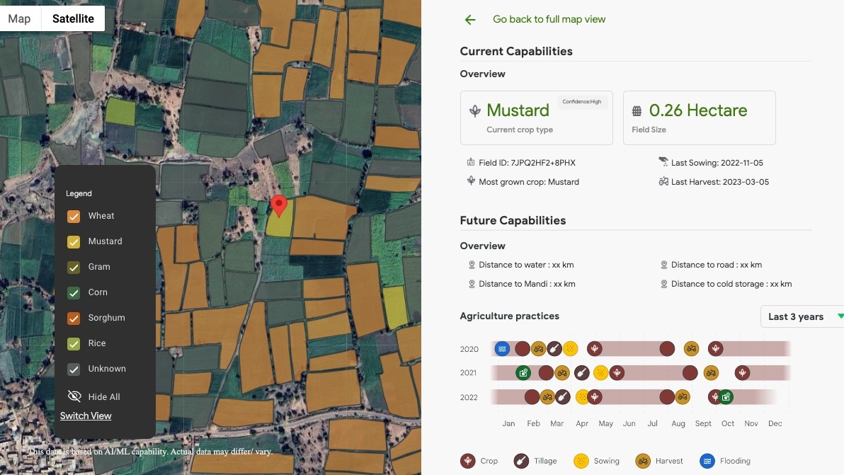
Agricultural Landscape Understanding (ALU): Launched in India in October 2024, this is the first layer. As Avneet Singh described, “ALU is our effort at segmenting the agricultural landscape into multiple classes.” Using satellite imagery, it identifies and draws boundaries for individual fields, water bodies, and vegetation, essentially creating a detailed digital map of the agricultural landscape.
Agricultural Monitoring and Event Detection (AMED): Building on ALU, the AMED API, released in July 2025, provides dynamic insights. “This is where we actually start looking at what is happening at an individual field,” Singh said. AMED can identify the current crop being grown, calculate the acreage of the field, and track key events like sowing and harvesting dates. Crucially, its data is refreshed every 15 days, allowing for near real-time monitoring.
Together, these models provide a powerful, unbiased dataset that was previously unavailable. “We are unlocking a flood of data that was previously not available,” Talekar stated. “This launch announcement is not the end of the journey, but it’s the start of a journey where we expect partners will start using this data.”
How It Works: Data, Accuracy, and Google’s Unique Edge
Powering these models is a massive trove of geospatial data. “Primarily, all of these models depend on earth observation data, largely coming from satellite imagery, either public satellite imagery or licensed satellite imagery that Google has,” Talekar clarified.
He explained that Google’s decades of investment in geospatial technologies like Google Maps provide a unique advantage. This unlocks capabilities that were once the exclusive domain of massive agricultural corporations for smallholder farmers.
But with AI, accuracy and bias are always key concerns. Talekar was candid about the challenges. “Any model that’s working at such massive scales… is not going to be perfectly accurate everywhere. Anybody can go and find some field that we get wrong,” he admitted. “But what is the statistical accuracy you need at scale that enables this to be useful? That is a question that needs to be answered for each use case specifically.”
To ensure the models are useful, Google employs a multi-pronged validation strategy, including standard machine learning checks, comparison with aggregate government census data, and independent spot checks by third parties like the startup TerraStac and the Government of Telangana.
The Real-World Impact: From Crop Yield to Credit Access
So, how does this technology benefit a farmer who has little knowledge of APIs or AI? The impact is delivered through the ecosystem partners who use Google’s models.
Avneet Singh provided a practical example: an AgriTech company aiming to help farmers maximise crop yield. “They can at scale for any district, any block, any region, identify which fields have their crop… and they can provide that intervention,” he said. The API tells them when the crop was sown and its history, allowing for highly targeted and effective advice.
Perhaps even more transformative is the impact on financial access. Alok Talekar painted a vivid picture of the current credit landscape for many farmers. “They generally can’t approach a bank directly because the cost for the bank to verify the farmer is doing… growing some crop… is too cumbersome,” he explained. “The cost of sending somebody over is too large; it’s comparable to the loan size oftentimes.” This pushes farmers towards secondary markets with predatory loan rates.
Google’s models offer a solution by providing an unbiased, low-cost way to verify farming activity. This reduces the risk and cost for financial institutions, potentially unlocking fair and accessible credit for millions. In India, the fintech company Sugee.io is already integrating the APIs’ insights to support efficiencies in loan application and management.
An Ecosystem in Bloom
In India, the models are already being deployed in various critical projects:
Krishi DSS: The ALU and AMED APIs are being integrated into this national platform for the Department of Agriculture, helping policymakers make informed decisions.
Government of Telangana: The state uses the models on its AdEx platform, an open data exchange for agricultural solutions.
Council on Energy, Environment and Water (CEEW): The think tank plans to use the APIs to design a new mechanism for differentiated income support, nudging farmers toward more climate-friendly crops.
A Global Vision, Born in India
The success of this ecosystem-led approach in India is the driving force behind the expansion to Malaysia, Indonesia, Vietnam, and Japan.
In the official announcement, Talekar stated, “We’re excited and hopeful that, in expanding the benefits of these APIs to APAC, we will see similar impact and potential unfold across the region, delivering to a conviction that we’ve held throughout our AI journey in India: that solutions that address India’s most pressing challenges can also solve for the world.”
When asked about data privacy, Singh was emphatic. The data is purely geospatial and contains no Personally Identifiable Information (PII). “There is no ownership construct within this,” he asserted, ensuring that farmer privacy is protected.
Related Posts